Geolocate

Porcon topographic map

Click on the map to display elevation.

About this map

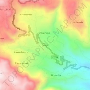
Name: Porcon topographic map, elevation, terrain.

Location: Porcon, Cajamarca, Perú (-7.10744 -78.60068 -7.06744 -78.56068)

Average elevation: 3,271 m

Minimum elevation: 2,932 m

Maximum elevation: 3,605 m

Other topographic maps

Click on a map to view its topography, its elevation and its terrain.

Río Mashcón

Perú > Cajamarca > Cajamarca

Average elevation: 2,905 m

Gear up for your next adventure:

🥾Lightweight Hiking Boots - Boots for comfort and mobility on long hikes
🦶Anti-Blister Balm - Prevents friction and hotspots during long ascents
❄️Traction Ice Cleats - Slip-on spikes for icy trails and winter hiking
🛶Kayak Dry Bag - Waterproof storage for kayaking adventures
💡Portable Camping Lamp - Rechargeable lamp for campsite lighting

As an Amazon Associate, this site earns from qualifying purchases at no extra cost to you.