
Thank you for supporting this site ❤️
Make a donation
Make a donation
Gear up for your next adventure:
As an Amazon Associate, this site earns from qualifying purchases at no extra cost to you.
Scheggia topographic map
Click on the map to display elevation.
Thank you for supporting this site ❤️
Make a donation
Make a donation
Gear up for your next adventure:
As an Amazon Associate, this site earns from qualifying purchases at no extra cost to you.
About this map
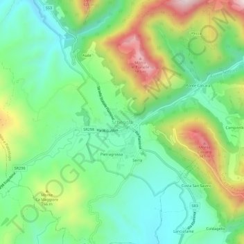
Name: Scheggia topographic map, elevation, terrain.
Location: Scheggia, Scheggia e Pascelupo, Perugia, Umbrië, 06027, Italië (43.38385 12.64606 43.42385 12.68606)
Average elevation: 658 m
Minimum elevation: 471 m
Maximum elevation: 1,011 m
Thank you for supporting this site ❤️
Make a donation
Make a donation
Gear up for your next adventure:
As an Amazon Associate, this site earns from qualifying purchases at no extra cost to you.