
Make a donation
Gear up for your next adventure:
As an Amazon Associate, this site earns from qualifying purchases at no extra cost to you.
Lalganj topographic map
Click on the map to display elevation.
Make a donation
Gear up for your next adventure:
As an Amazon Associate, this site earns from qualifying purchases at no extra cost to you.
About this map
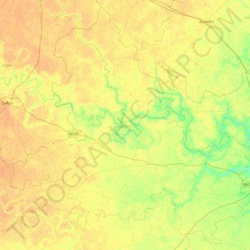
Name: Lalganj topographic map, elevation, terrain.
Location: Lalganj, Pratapgarh, Uttar Pradesh, India (25.80515 81.45277 26.18069 81.89363)
Average elevation: 103 m
Minimum elevation: 86 m
Maximum elevation: 112 m
Make a donation
Gear up for your next adventure:
As an Amazon Associate, this site earns from qualifying purchases at no extra cost to you.
Other topographic maps
Click on a map to view its topography, its elevation and its terrain.
Kunda
India > Uttar Pradesh > Pratāpgarh
Kunda is located at 25°43′N 81°31′E / 25.72°N 81.52°E / 25.72; 81.52. It has an average elevation of 9 metres (291 feet). Kunda is not a very old town and probably was founded during the British Raj. Kunda is Located on Prayagraj-Lucknow National Highway 24B. Place is developing as main…
Average elevation: 103 m