Geolocate

Lilliwaup topographic map

Click on the map to display elevation.

About this map

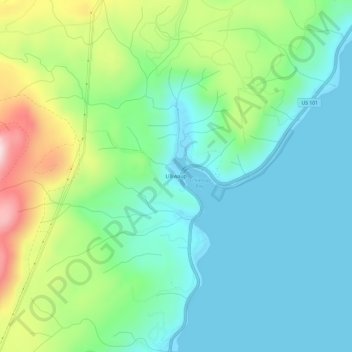
Name: Lilliwaup topographic map, elevation, terrain.

Location: Lilliwaup, Mason County, Washington, United States (47.44258 -123.13590 47.48258 -123.09590)

Average elevation: 114 m

Minimum elevation: -2 m

Maximum elevation: 411 m

Other topographic maps

Click on a map to view its topography, its elevation and its terrain.

Shelton

United States > Washington > Mason County

Average elevation: 54 m

Allyn

United States > Washington > Mason County > Allyn

Average elevation: 47 m

Belfair

United States > Washington > Mason County

Average elevation: 65 m

Oakland Bay

United States > Washington > Mason County > Shelton

Average elevation: 36 m

Price Lake

United States > Washington > Mason County

Average elevation: 326 m

Allyn

United States > Washington > Mason County > Allyn

Average elevation: 47 m

Lake Cushman

United States > Washington > Mason County

Average elevation: 410 m

Belfair

United States > Washington > Mason County

Average elevation: 65 m

Grapeview

United States > Washington > Mason County

Average elevation: 17 m

Gear up for your next adventure:

Camping Coffee Maker - Brew fresh coffee anywhere on the topographic map
🥾Approach Shoes - Shoes designed for climbing approaches and rugged trails
💧Reusable Water Bottle - Durable water bottles for hydration on trails
🐕Hiking Dog Pack - Let your canine companion carry their own water and food
🩹Moleskin Blister Pads - Direct protection for painful foot pressure points

As an Amazon Associate, this site earns from qualifying purchases at no extra cost to you.