Geolocate

Yumthang topographic map

Click on the map to display elevation.

About this map

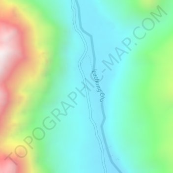
Name: Yumthang topographic map, elevation, terrain.

Location: Yumthang, Chungthang, Mangan, Sikkim, India (27.79426 88.69332 27.81426 88.71332)

Average elevation: 3,935 m

Minimum elevation: 3,589 m

Maximum elevation: 4,816 m

Other topographic maps

Click on a map to view its topography, its elevation and its terrain.

Lachung Chu

India > Sikkim > Chungthang > Lachung

Average elevation: 4,332 m

South Lhonak Glacier

India > Sikkim > Chungthang

Average elevation: 5,830 m

Gurudongmar

India > Sikkim > Chungthang

Gurudongmar Lake is one of the highest lakes in the world and in India, at an elevation of 5,430 m (17,800 ft) according to the Government of Sikkim. It is located in the Great Himalayas in the Mangan District in Indian state of Sikkim, and considered sacred by Buddhists and Sikhs. The lake is named after…

Average elevation: 5,232 m

Zemu Chu

India > Sikkim > Chungthang

Average elevation: 3,657 m

Zemu Glacier

India > Sikkim > Chungthang

Average elevation: 5,510 m

Gear up for your next adventure:

🛶Canoe Life Vest - Safety vest for water sports
🛁Quick-Dry Microfiber Towel - Space-saving towel that dries rapidly on the move
🧥Packable Rain Jacket - Breathable waterproof layer for unpredictable weather
👟Sport Hiking Sandals - Breathable footwear for water crossings and camp rest
💡Compact LED Flashlight - Powerful and portable flashlight for outdoor use

As an Amazon Associate, this site earns from qualifying purchases at no extra cost to you.