Geolocate

Marianna topographic map

Click on the map to display elevation.

About this map

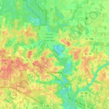
Name: Marianna topographic map, elevation, terrain.

Location: Marianna, Jackson County, Florida, 32447, United States (30.73335 -85.28417 30.85586 -85.16404)

Average elevation: 39 m

Minimum elevation: 15 m

Maximum elevation: 67 m

Other topographic maps

Click on a map to view its topography, its elevation and its terrain.

Compass Lake

United States > Florida > Jackson County

Average elevation: 66 m

Haynes

United States > Florida > Jackson County > Haynes

Average elevation: 28 m

Cypress

United States > Florida > Jackson County > Cypress

Average elevation: 41 m

Gear up for your next adventure:

🛌Down Sleeping Bag - Superior warmth-to-weight ratio for cold nights
🧰Survival Kit - Essential gear for emergencies in the wilderness
🔭Compact Binoculars - Lightweight optics for scouting trails and wildlife
💧Hydration Pack - Hands-free hydration system for long hikes
🥾Hiking Shoes - Durable and comfortable shoes for trail hiking

As an Amazon Associate, this site earns from qualifying purchases at no extra cost to you.