Geolocate

Catarman topographic map

Click on the map to display elevation.

About this map

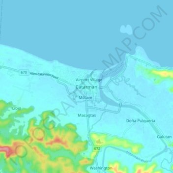
Name: Catarman topographic map, elevation, terrain.

Location: Catarman, Northern Samar, Eastern Visayas, 6400, Philippines (12.45966 124.59659 12.53966 124.67659)

Average elevation: 11 m

Minimum elevation: -2 m

Maximum elevation: 112 m

Gear up for your next adventure:

🥾Mountain Trail Shoes - High-traction shoes for mountain trails
Family Camping Tent - Spacious tent suitable for family camping trips
🍽️Titanium Camping Spork - Ultralight and indestructible eating utensil
🕶️Polarized Sunglasses - Reduces glare from snow and water at high elevations
Camping Groundsheet - Protect your tent from moisture and dirt

As an Amazon Associate, this site earns from qualifying purchases at no extra cost to you.