
Make a donation
Gear up for your next adventure:
As an Amazon Associate, this site earns from qualifying purchases at no extra cost to you.
La Florida topographic map
Click on the map to display elevation.
Make a donation
Gear up for your next adventure:
As an Amazon Associate, this site earns from qualifying purchases at no extra cost to you.
About this map
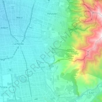
Name: La Florida topographic map, elevation, terrain.
Average elevation: 963 m
Minimum elevation: 544 m
Maximum elevation: 2,830 m
Make a donation
Gear up for your next adventure:
As an Amazon Associate, this site earns from qualifying purchases at no extra cost to you.
Other topographic maps
Click on a map to view its topography, its elevation and its terrain.
Cerro Santa Lucía
Chile > Región Metropolitana de Santiago > Provincia de Santiago > Santiago
El cerro Santa Lucía, antiguamente llamado cerro Huelén en picunche, es un parque urbano ubicado en el corazón de la ciudad de Santiago de Chile. Limita al sur con la Avenida Libertador General Bernardo O'Higgins, donde se encuentra la estación Santa Lucía del Metro de Santiago, al oeste con la calle…
Average elevation: 573 m
Parque O'Higgins
Chile > Región Metropolitana de Santiago > Provincia de Santiago > Santiago
Average elevation: 536 m
Bosque Santiago
Chile > Región Metropolitana de Santiago > Provincia de Santiago > Huechuraba
Average elevation: 773 m
Parque Mahuida
Chile > Región Metropolitana de Santiago > Provincia de Santiago
Average elevation: 867 m
Make a donation
Gear up for your next adventure:
As an Amazon Associate, this site earns from qualifying purchases at no extra cost to you.
Parque de la Familia
Chile > Región Metropolitana de Santiago > Provincia de Santiago > Quinta Normal
Average elevation: 529 m
Laguna Carén
Chile > Región Metropolitana de Santiago > Provincia de Santiago > Pudahuel > Carén
Average elevation: 464 m
Laguna Agostini
Chile > Región Metropolitana de Santiago > Provincia de Santiago > Lo Barnechea
Average elevation: 4,456 m
Make a donation
Gear up for your next adventure:
As an Amazon Associate, this site earns from qualifying purchases at no extra cost to you.
La Parva
Chile > Región Metropolitana de Santiago > Provincia de Santiago > Lo Barnechea
Average elevation: 2,831 m
Parque Lo Errazuriz
Chile > Región Metropolitana de Santiago > Provincia de Santiago > Cerrillos
Average elevation: 495 m
Plaza Libertad
Chile > Región Metropolitana de Santiago > Provincia de Santiago > Santiago
Average elevation: 559 m
Cerro Primo de Rivera
Chile > Región Metropolitana de Santiago > Provincia de Santiago
Average elevation: 479 m
Make a donation
Gear up for your next adventure:
As an Amazon Associate, this site earns from qualifying purchases at no extra cost to you.
Plaza Las Águilas
Chile > Región Metropolitana de Santiago > Provincia de Santiago > La Florida
Average elevation: 611 m
Plaza del reloj
Chile > Región Metropolitana de Santiago > Provincia de Santiago
Average elevation: 766 m
Mirador San Cristóbal
Chile > Región Metropolitana de Santiago > Provincia de Santiago > Las Condes
Average elevation: 765 m
Cerro El Carbón
Chile > Región Metropolitana de Santiago > Provincia de Santiago > Huechuraba
Average elevation: 945 m
Make a donation
Gear up for your next adventure:
As an Amazon Associate, this site earns from qualifying purchases at no extra cost to you.