Geolocate

les Preses topographic map

Click on the map to display elevation.

About this map

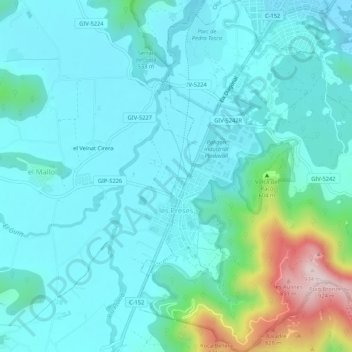
Name: les Preses topographic map, elevation, terrain.

Location: les Preses, Garrotxa, Girona, Catalonia, 17178, Spain (42.12923 2.45365 42.16867 2.49816)

Average elevation: 520 m

Minimum elevation: 439 m

Maximum elevation: 914 m

Other topographic maps

Click on a map to view its topography, its elevation and its terrain.

Pallerols

Spain > Catalonia > Garrotxa > Sant Feliu de Pallerols

Average elevation: 608 m

Besalú

Spain > Catalonia > Garrotxa > Besalú > Besalú

Average elevation: 225 m

Olot

Spain > Catalonia > Garrotxa > Olot > Olot

Average elevation: 489 m

Begudà

Spain > Catalonia > Garrotxa > Sant Joan les Fonts > Begudà

Average elevation: 491 m

Beuda

Spain > Catalonia > Garrotxa > Beuda > Beuda

Average elevation: 460 m

Gear up for your next adventure:

🧤Thermal Hiking Gloves - Grip-enhanced gloves for cold-weather altitude trekking
🧥Softshell Jacket - Windproof and breathable jacket for hiking
🧭GPS Handheld Device - Reliable GPS navigation for outdoor adventures
📷Outdoor Action Camera - Capture high-elevation views and rugged adventures
💧Hydration Bladder - Hands-free hydration solution for long treks

As an Amazon Associate, this site earns from qualifying purchases at no extra cost to you.