
Thank you for supporting this site ❤️
Make a donation
Make a donation
Gear up for your next adventure:
As an Amazon Associate, this site earns from qualifying purchases at no extra cost to you.
La Roche-sur-Yon topographic map
Click on the map to display elevation.
Thank you for supporting this site ❤️
Make a donation
Make a donation
Gear up for your next adventure:
As an Amazon Associate, this site earns from qualifying purchases at no extra cost to you.
La Roche-sur-Yon
Le territoire municipal de La Roche-sur-Yon s’étend sur 8 779 hectares. L’altitude moyenne de la commune est de 68 mètres, avec des niveaux fluctuant entre 32 et 94 mètres,.
Thank you for supporting this site ❤️
Make a donation
Make a donation
Gear up for your next adventure:
As an Amazon Associate, this site earns from qualifying purchases at no extra cost to you.
About this map
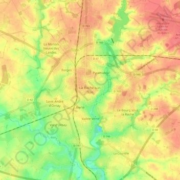
Name: La Roche-sur-Yon topographic map, elevation, terrain.
Average elevation: 65 m
Minimum elevation: 26 m
Maximum elevation: 93 m
Thank you for supporting this site ❤️
Make a donation
Make a donation
Gear up for your next adventure:
As an Amazon Associate, this site earns from qualifying purchases at no extra cost to you.