
Make a donation
Gear up for your next adventure:
As an Amazon Associate, this site earns from qualifying purchases at no extra cost to you.
Caswell Beach topographic map
Click on the map to display elevation.
Make a donation
Gear up for your next adventure:
As an Amazon Associate, this site earns from qualifying purchases at no extra cost to you.
Caswell Beach
Roughly halfway distant from Wilmington, North Carolina and Myrtle Beach, South Carolina, Caswell Beach is located on the east end of Oak Island. This island is the easternmost of the South Brunswick Islands which were formed in the late 1930s by the construction of the Intracoastal Waterway (ICW) which was dredged from Southport, NC at the mouth of the Cape Fear River through coastal sounds and marshes to the Little River in South Carolina. Elevations in the town range from sea level to approximately 25'while the town has a total area of 4.1 square miles (10.5 km2), of which 2.9 square miles (7.6 km2) is land.
Make a donation
Gear up for your next adventure:
As an Amazon Associate, this site earns from qualifying purchases at no extra cost to you.
About this map
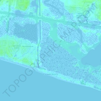
Name: Caswell Beach topographic map, elevation, terrain.
Average elevation: 1 m
Minimum elevation: -4 m
Maximum elevation: 9 m
Make a donation
Gear up for your next adventure:
As an Amazon Associate, this site earns from qualifying purchases at no extra cost to you.
Other topographic maps
Click on a map to view its topography, its elevation and its terrain.
Bald Head Island
United States > North Carolina > Brunswick County > Bald Head Island
Average elevation: 3 m
Make a donation
Gear up for your next adventure:
As an Amazon Associate, this site earns from qualifying purchases at no extra cost to you.
Boiling Spring Lake Dam
United States > North Carolina > Brunswick County > Boiling Spring Lakes
Average elevation: 14 m
Make a donation
Gear up for your next adventure:
As an Amazon Associate, this site earns from qualifying purchases at no extra cost to you.
Make a donation
Gear up for your next adventure:
As an Amazon Associate, this site earns from qualifying purchases at no extra cost to you.
Make a donation
Gear up for your next adventure:
As an Amazon Associate, this site earns from qualifying purchases at no extra cost to you.