Geolocate

Summerlin South topographic map

Click on the map to display elevation.

About this map

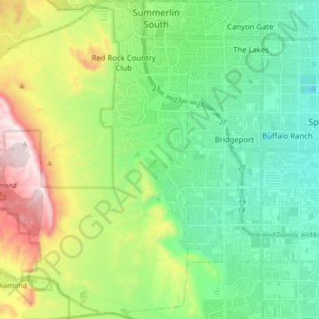
Name: Summerlin South topographic map, elevation, terrain.

Location: Summerlin South, Clark County, Nevada, United States (36.03301 -115.45016 36.15898 -115.31503)

Average elevation: 935 m

Minimum elevation: 690 m

Maximum elevation: 1,505 m

Gear up for your next adventure:

🛶Kayak Accessories - Essential gear for safe and fun kayaking adventures
🧦Outdoor Socks - Durable socks designed for hiking and outdoor sports
🛰️Satellite Messenger - Emergency communication for areas with no cell service
Camping Tent - Weather-resistant tents suitable for 2 to 6 people
🥾Trekking Poles - Adjustable trekking poles to reduce knee stress and improve stability

As an Amazon Associate, this site earns from qualifying purchases at no extra cost to you.