Geolocate

Santacruz topographic map

Click on the map to display elevation.

About this map

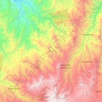
Name: Santacruz topographic map, elevation, terrain.

Location: Santacruz, Los Abades, Nariño, Colombia (1.09135 -77.86380 1.46395 -77.61243)

Average elevation: 2,095 m

Minimum elevation: 323 m

Maximum elevation: 3,951 m

Gear up for your next adventure:

🔭Compact Monocular - One-handed bird watching and trail spotting
🧥Ultralight Puffy Jacket - Maximum warmth that packs down to the size of an orange
🧦Merino Wool Socks - Moisture-wicking comfort for long-distance hiking
🔦UV Flashlight - Detect minerals or specific insects in the dark
🥤Collapsible Travel Cup - Saves space and weight in your mess kit

As an Amazon Associate, this site earns from qualifying purchases at no extra cost to you.