
Skútustaðahreppur topographic map
Interactive map
Click on the map to display elevation.
About this map
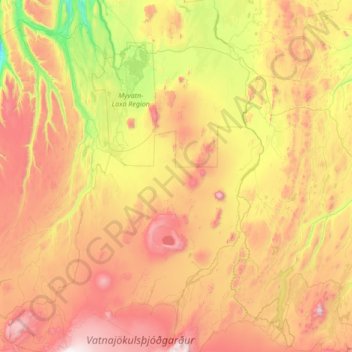
Name: Skútustaðahreppur topographic map, elevation, terrain.
Location: Skútustaðahreppur, Norðurland eystra, 660, Islande (64.66128 -17.33507 65.80888 -16.00546)
Average elevation: 661 m
Minimum elevation: -1 m
Maximum elevation: 1,903 m
Other topographic maps
Click on a map to view its topography, its elevation and its terrain.
卡拉夫拉火山
卡拉夫拉火山, Kröfluvegur, Skútustaðahreppur, Norðurland eystra, Islande
Average elevation: 588 m