Geolocate

Saint Joseph topographic map

Click on the map to display elevation.

About this map

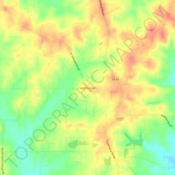
Name: Saint Joseph topographic map, elevation, terrain.

Location: Saint Joseph, Vanderburgh County, Indiana, United States (38.04615 -87.66696 38.08615 -87.62696)

Average elevation: 156 m

Minimum elevation: 127 m

Maximum elevation: 178 m

Other topographic maps

Click on a map to view its topography, its elevation and its terrain.

Evansville

United States > Indiana > Vanderburgh County

Average elevation: 122 m

Evansville

United States > Indiana > Vanderburgh County

Average elevation: 122 m

Highland

United States > Indiana > Vanderburgh County

Average elevation: 133 m

Highland

United States > Indiana > Vanderburgh County

Average elevation: 133 m

Evansville

United States > Indiana > Vanderburgh County

Average elevation: 124 m

Darmstadt

United States > Indiana > Vanderburgh County

Average elevation: 143 m

Gear up for your next adventure:

🥾Mountain Hiking Boots - High-traction boots for rocky terrain
🧦Merino Wool Socks - Moisture-wicking comfort for long-distance hiking
🕶️Polarized Sunglasses - Reduces glare from snow and water at high elevations
🔦UV Flashlight - Detect minerals or specific insects in the dark
🥾Hiking Gaiters - Protect legs and shoes from mud, snow, and debris

As an Amazon Associate, this site earns from qualifying purchases at no extra cost to you.