Geolocate

Salitran topographic map

Click on the map to display elevation.

About this map
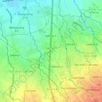
Name: Salitran topographic map, elevation, terrain.

Location: Salitran, Dasmariñas, Cavite, Calabarzon, Philippines (14.33602 120.92983 14.36206 120.96754)

Average elevation: 61 m

Minimum elevation: 37 m

Maximum elevation: 95 m

Other topographic maps

Click on a map to view its topography, its elevation and its terrain.
Luksuhin Dam

Philippines > Cavite > Dasmarinas

Average elevation: 127 m

Mango Village

Philippines > Cavite > Dasmarinas

Average elevation: 63 m

Pasong Tinta

Philippines > Cavite > Dasmarinas

Average elevation: 79 m

Piela

Philippines > Cavite > Dasmarinas > Piela

Average elevation: 170 m

Humayao

Philippines > Cavite > Dasmarinas

Average elevation: 202 m

Tibagan

Philippines > Cavite > Dasmarinas

Average elevation: 72 m

Malipay

Philippines > Cavite > Dasmarinas

Average elevation: 71 m

Gear up for your next adventure:

🧭GPS Outdoor Watch - Smart watch for navigation and fitness tracking in nature
⛺Lightweight Backpacking Tent - Compact tent for efficient hiking trips
🚲Heavy Duty Bike Lock - Secure your bike at the trailhead or during stops
🛌Down Sleeping Bag - Superior warmth-to-weight ratio for cold nights
🔪Outdoor Multitool - Versatile tool for repairs and food prep in the wild

As an Amazon Associate, this site earns from qualifying purchases at no extra cost to you.