
Make a donation
Gear up for your next adventure:
As an Amazon Associate, this site earns from qualifying purchases at no extra cost to you.
Aydat topographic map
Click on the map to display elevation.
Make a donation
Gear up for your next adventure:
As an Amazon Associate, this site earns from qualifying purchases at no extra cost to you.
Aydat
Le plateau d'altitude, ou des Dômes, ouvert et « légèrement vallonné », offre un panorama sur la chaîne des Puys, le massif du Sancy, la Limagne et le Livradois. L'altitude varie de 900 à plus de 1 000 mètres. Quelques villages de la commune sont situés sur ces plateaux, comme Verneuge ou Phialeix.
Make a donation
Gear up for your next adventure:
As an Amazon Associate, this site earns from qualifying purchases at no extra cost to you.
About this map
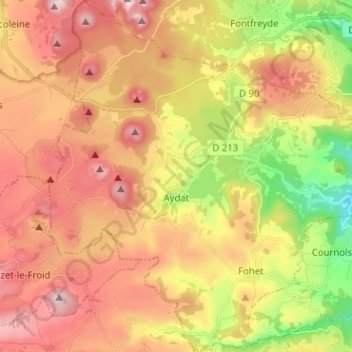
Name: Aydat topographic map, elevation, terrain.
Average elevation: 938 m
Minimum elevation: 673 m
Maximum elevation: 1,165 m
Make a donation
Gear up for your next adventure:
As an Amazon Associate, this site earns from qualifying purchases at no extra cost to you.