
Make a donation
Gear up for your next adventure:
As an Amazon Associate, this site earns from qualifying purchases at no extra cost to you.
Osthafen topographic map
Click on the map to display elevation.
Make a donation
Gear up for your next adventure:
As an Amazon Associate, this site earns from qualifying purchases at no extra cost to you.
About this map
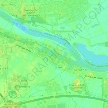
Name: Osthafen topographic map, elevation, terrain.
Location: Osthafen, Irl, Regensburg, Bayern, 93055, Deutschland (49.00117 12.15830 49.02117 12.17830)
Average elevation: 331 m
Minimum elevation: 322 m
Maximum elevation: 340 m
Make a donation
Gear up for your next adventure:
As an Amazon Associate, this site earns from qualifying purchases at no extra cost to you.
Other topographic maps
Click on a map to view its topography, its elevation and its terrain.
Schloss Pürkelgut
Deutschland > Bayern > Regensburg
Das heutige Schloss Pürkelgut liegt im südöstlichen Regensburger Stadtbezirk Kasernenviertel, das im Süden von der Ost-West-Autobahn A3 begrenzt wird. Südlich der Autobahn liegt der Regensburger Stadtbezirk Burgweinting-Harting. Die Autobahn verläuft auf dem Höhenrücken des geologisch als Hochterrasse…
Average elevation: 339 m