Geolocate

Ijen topographic map

Click on the map to display elevation.

About this map

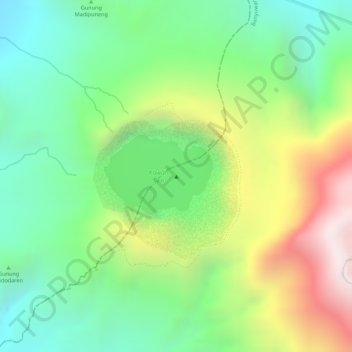
Name: Ijen topographic map, elevation, terrain.

Location: Ijen, Banyuwangi, East Java, Java, Indonesia (-8.05798 114.24305 -8.05788 114.24315)

Average elevation: 2,200 m

Minimum elevation: 1,841 m

Maximum elevation: 2,750 m

Other topographic maps

Click on a map to view its topography, its elevation and its terrain.

DESA KALIPAIT

Indonesia > East Java > Banyuwangi

Average elevation: 47 m

DESA SUMBERASRI

Indonesia > East Java > Banyuwangi

Average elevation: 13 m

Gear up for your next adventure:

🛶Kayak Accessories - Essential gear for safe and fun kayaking adventures
Camping Essentials - All-in-one gear for a comfortable camping trip
🔦UV Flashlight - Detect minerals or specific insects in the dark
💧Filtered Water Bottle - Safe drinking water on the go
🧴Outdoor Sunscreen - High SPF protection for high-altitude UV exposure

As an Amazon Associate, this site earns from qualifying purchases at no extra cost to you.