
Cape Cod topographic map
Click on the map to display elevation.
Cape Cod
Cape Cod extends 65 miles (105 km) into the Atlantic Ocean, with a breadth of between 1–20 miles (1.6–32.2 km), and covers more than 400 miles (640 km) of shoreline. Its elevation ranges from 306 feet (93 m) at its highest point, at the top of Pine Hill, in the Bourne portion of Joint Base Cape Cod, down to sea level.
About this map
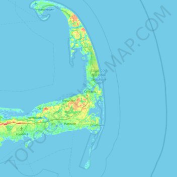
Name: Cape Cod topographic map, elevation, terrain.
Location: Cape Cod, Barnstable County, Massachusetts, United States (41.51497 -70.68798 42.08253 -69.92900)
Average elevation: 2 m
Minimum elevation: -6 m
Maximum elevation: 56 m
Other topographic maps
Click on a map to view its topography, its elevation and its terrain.
South Dennis
United States > Massachusetts > Barnstable County > Dennis > South Dennis
Average elevation: 9 m
CR #10
United States > Massachusetts > Barnstable County > Falmouth > Saconesset Hills
Average elevation: 14 m