Geolocate

Eden topographic map

Click on the map to display elevation.

About this map
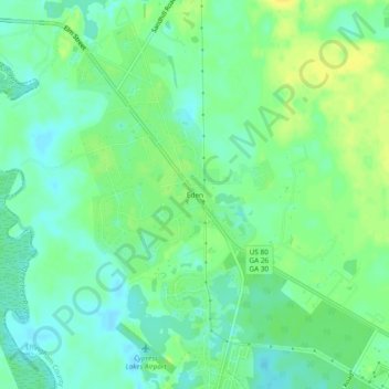
Name: Eden topographic map, elevation, terrain.

Location: Eden, Effingham County, Georgia, 31307, United States (32.15381 -81.41067 32.19381 -81.37067)

Average elevation: 11 m

Minimum elevation: 1 m

Maximum elevation: 24 m

Other topographic maps

Click on a map to view its topography, its elevation and its terrain.
Rincon

United States > Georgia > Effingham County

Average elevation: 19 m

Springfield

United States > Georgia > Effingham County

Average elevation: 25 m

Guyton

United States > Georgia > Effingham County

Average elevation: 26 m

Rincon

United States > Georgia > Effingham County

Average elevation: 19 m

Gear up for your next adventure:

🥾Trail Running Boots - Durable shoes designed for trail running
🥾Waterproof Hiking Shoes - Durable shoes for wet and rugged trails
🔨Vehicle Emergency Tool - Safety tool for remote road trips to trailheads
🥾Waterproof Hiking Boots - Boots keeping your feet dry in wet conditions
🎒Hiking Backpack - Lightweight and ergonomic backpacks for day hikes or multi-day treks

As an Amazon Associate, this site earns from qualifying purchases at no extra cost to you.