Geolocate

Lapstone topographic map

Interactive map

Click on the map to display elevation.

Lapstone

Lapstone is a township on the eastern escarpment of the Blue Mountains in New South Wales, Australia. Elevation 160 m (525 ft). Lapstone is located 62 kilometres west of the Sydney CBD in the local government area of the City of Blue Mountains and is part of the federal electorate of Macquarie. Lapstone consists mostly of stand-alone housing and has a few public facilities. At the 2016 census, Lapstone had a population of 961 people. Lapstone was originally bought and developed by Mr Arthur J Hand, an Alderman of the Blue Mountains City Council.

Wikipedia (CC-BY-SA 3.0)

About this map

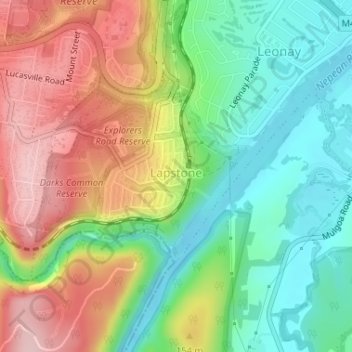
Name: Lapstone topographic map, elevation, terrain.

Location: Lapstone, Sydney, Blue Mountains City Council, New South Wales, 2773, Australia (-33.78263 150.62815 -33.76661 150.64289)

Average elevation: 109 m

Minimum elevation: 16 m

Maximum elevation: 232 m

Other topographic maps

Click on a map to view its topography, its elevation and its terrain.

Mount Annan

Australia > New South Wales > Sydney

Average elevation: 115 m

Rose Seidler House

Australia > New South Wales > Sydney

Average elevation: 153 m

Herron Park

Australia > New South Wales > Sydney

Average elevation: 28 m

Dark Gully Reserve

Australia > New South Wales > Sydney

Average elevation: 14 m

The Islands

Australia > New South Wales > Sydney > The Islands

Average elevation: 303 m

Sovereign

Australia > New South Wales > Sydney > Sovereign

Average elevation: 72 m

Bay Gardens

Australia > New South Wales > Sydney > Bay Gardens

Average elevation: 22 m

Sydney Smith Park

Australia > New South Wales > Sydney

Average elevation: 29 m