

Werdohl topographic map
Click on the map to display elevation.
Werdohl
Werdohl is located in the hills of the Sauerland, at a double meander of the river Lenne and its confluent, the Verse. The highest elevation is the Hölzerne Klinke with 448.8m above sea level, the lowest is in valley of Lenne at the boundary to the city Altena with 162m. Werdohl shares borders with (clockwise) Altena, Neuenrade, Plettenberg, Herscheid and Lüdenscheid. A large part of the area, about 19.2 km2, is meadows and forests and is used for agriculture and forestry, followed by 3.18 km2 of residential areas and 1.24 km2 are commercial and industrial areas.
About this map
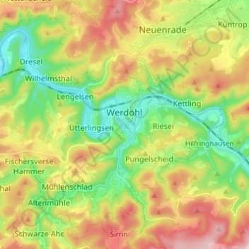
Name: Werdohl topographic map, elevation, terrain.
Average elevation: 332 m
Minimum elevation: 161 m
Maximum elevation: 568 m
Other topographic maps
Click on a map to view its topography, its elevation and its terrain.

Rotthausen
Germany > North Rhine-Westphalia > Märkischer Kreis > Schalksmühle
Average elevation: 343 m
Gelstern
Germany > North Rhine-Westphalia > Märkischer Kreis > Schalksmühle > Heedfeld
Average elevation: 385 m
Moßberg
Germany > North Rhine-Westphalia > Märkischer Kreis > Menden (Sauerland)
Average elevation: 220 m
Blechen
Germany > North Rhine-Westphalia > Märkischer Kreis > Kierspe > Blechen
Average elevation: 376 m