
Walau topographic map
Interactive map
Click on the map to display elevation.
About this map
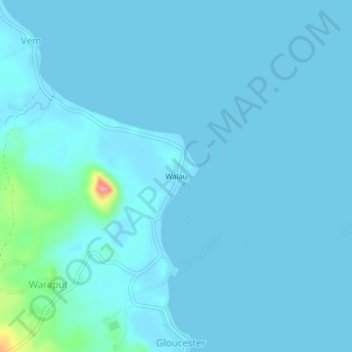
Name: Walau topographic map, elevation, terrain.
Location: Walau, West New Britain, Islands Region, Papua New Guinea (-5.52177 148.49841 -5.48177 148.53841)
Average elevation: 8 m
Minimum elevation: -1 m
Maximum elevation: 116 m
Other topographic maps
Click on a map to view its topography, its elevation and its terrain.
Gloucester
Papua New Guinea > West New Britain > Gloucester
Gloucester, West New Britain, Islands Region, Papua New Guinea
Average elevation: 21 m
Seleng
Papua New Guinea > West New Britain > Seleng
Seleng, West New Britain, Islands Region, Papua New Guinea
Average elevation: 74 m
Lolobau Island
Papua New Guinea > West New Britain
Lolobau Island, Hoskins District, West New Britain, Islands Region, Papua New Guinea
Average elevation: 74 m
Kimbe
Papua New Guinea > West New Britain > Kimbe
Kimbe, Kandrian District, West New Britain, Islands Region, Papua New Guinea
Average elevation: 87 m