
Make a donation
Gear up for your next adventure:
As an Amazon Associate, this site earns from qualifying purchases at no extra cost to you.
Mine Hill topographic map
Click on the map to display elevation.
Make a donation
Gear up for your next adventure:
As an Amazon Associate, this site earns from qualifying purchases at no extra cost to you.
Mine Hill
According to the United States Census Bureau, the township had a total area of 3.00 square miles (7.76 km2), including 2.94 square miles (7.61 km2) of land and 0.06 square miles (0.15 km2) of water (1.93%). The township is at an elevation of 863 feet (263 m) above sea level for the administrative center.
Make a donation
Gear up for your next adventure:
As an Amazon Associate, this site earns from qualifying purchases at no extra cost to you.
About this map
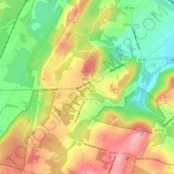
Name: Mine Hill topographic map, elevation, terrain.
Location: Mine Hill, Morris County, New Jersey, 07803, United States (40.86245 -74.62364 40.89814 -74.57820)
Average elevation: 245 m
Minimum elevation: 176 m
Maximum elevation: 312 m
Make a donation
Gear up for your next adventure:
As an Amazon Associate, this site earns from qualifying purchases at no extra cost to you.
Other topographic maps
Click on a map to view its topography, its elevation and its terrain.
Make a donation
Gear up for your next adventure:
As an Amazon Associate, this site earns from qualifying purchases at no extra cost to you.
Washington Valley
United States > New Jersey > Morris County > Morris Township
Average elevation: 152 m
Make a donation
Gear up for your next adventure:
As an Amazon Associate, this site earns from qualifying purchases at no extra cost to you.
Powder Mill Pond Dam
United States > New Jersey > Morris County > Parsippany-Troy Hills > Tabor
Average elevation: 178 m
Make a donation
Gear up for your next adventure:
As an Amazon Associate, this site earns from qualifying purchases at no extra cost to you.
Lake Parsippany
United States > New Jersey > Morris County > Parsippany-Troy Hills
Average elevation: 93 m
Pleasant Valley
United States > New Jersey > Morris County > Mendham Township
Average elevation: 156 m
Schooleys Mountain
United States > New Jersey > Morris County > Washington Township
Average elevation: 293 m
Make a donation
Gear up for your next adventure:
As an Amazon Associate, this site earns from qualifying purchases at no extra cost to you.
Make a donation
Gear up for your next adventure:
As an Amazon Associate, this site earns from qualifying purchases at no extra cost to you.
Calais Crossroads
United States > New Jersey > Morris County > Randolph Township
Average elevation: 284 m
Washington Corner
United States > New Jersey > Morris County > Mendham Township
Average elevation: 174 m
Make a donation
Gear up for your next adventure:
As an Amazon Associate, this site earns from qualifying purchases at no extra cost to you.
Make a donation
Gear up for your next adventure:
As an Amazon Associate, this site earns from qualifying purchases at no extra cost to you.
Make a donation
Gear up for your next adventure:
As an Amazon Associate, this site earns from qualifying purchases at no extra cost to you.
Mooney Mountain Park
United States > New Jersey > Morris County > Roxbury Township
Average elevation: 326 m
Lake Hiawatha
United States > New Jersey > Morris County > Parsippany-Troy Hills
Average elevation: 76 m
Lower Montville
United States > New Jersey > Morris County > Montville Township
Average elevation: 84 m
Make a donation
Gear up for your next adventure:
As an Amazon Associate, this site earns from qualifying purchases at no extra cost to you.
Beach Glen
United States > New Jersey > Morris County > Rockaway Township > Beach Glen
Average elevation: 209 m
Make a donation
Gear up for your next adventure:
As an Amazon Associate, this site earns from qualifying purchases at no extra cost to you.
Floral Hill
United States > New Jersey > Morris County > Chatham Township > Floral Hill
Average elevation: 90 m
Rockaway Valley
United States > New Jersey > Morris County > Boonton Township
Average elevation: 181 m
Make a donation
Gear up for your next adventure:
As an Amazon Associate, this site earns from qualifying purchases at no extra cost to you.
Roxbury Township
United States > New Jersey > Morris County > Roxbury Township
Average elevation: 264 m