Geolocate

Quezon topographic map

Click on the map to display elevation.

About this map

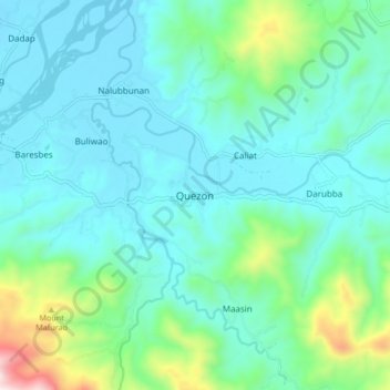
Name: Quezon topographic map, elevation, terrain.

Location: Quezon, Nueva Vizcaya, Cagayan Valley, Philippines (16.45019 121.22403 16.53019 121.30403)

Average elevation: 385 m

Minimum elevation: 234 m

Maximum elevation: 1,046 m

Other topographic maps

Click on a map to view its topography, its elevation and its terrain.

Kasibu River

Philippines > Nueva Vizcaya > Kasibu

Average elevation: 866 m

Kayapa

Philippines > Nueva Vizcaya

Average elevation: 1,258 m

Gear up for your next adventure:

🧢Beanie Hat - Keep your head warm in cold weather
💧Reusable Water Bottle - Durable water bottles for hydration on trails
🦶Hiking Shoe Insoles - Added support for high arches and long days on feet
🧥Waterproof Hiking Jacket - Protect yourself from rain and wind while hiking
🔭Outdoor Binoculars - Lightweight binoculars for birdwatching and hiking

As an Amazon Associate, this site earns from qualifying purchases at no extra cost to you.