Geolocate

Breckenridge topographic map

Click on the map to display elevation.

About this map

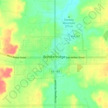
Name: Breckenridge topographic map, elevation, terrain.

Location: Breckenridge, Stephens County, Texas, United States (32.74423 -98.95102 32.77021 -98.88276)

Average elevation: 377 m

Minimum elevation: 353 m

Maximum elevation: 410 m

Other topographic maps

Click on a map to view its topography, its elevation and its terrain.

Caddo

United States > Texas > Stephens County

Average elevation: 397 m

Breckenridge

United States > Texas > Stephens County

Average elevation: 377 m

Gear up for your next adventure:

🦟Insect Repellent - Keep mosquitoes and black flies away in wooded areas
🧦Merino Wool Socks - Moisture-wicking comfort for long-distance hiking
🦶Anti-Blister Balm - Prevents friction and hotspots during long ascents
🧴Waterproofing Spray - Restore the DWR coating on jackets and tents
🛶Waterproof Dry Bags - Keep electronics and clothes dry during river crossings

As an Amazon Associate, this site earns from qualifying purchases at no extra cost to you.