Geolocate

Wallichen topographic map

Click on the map to display elevation.

About this map

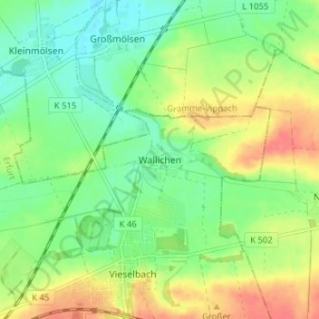
Name: Wallichen topographic map, elevation, terrain.

Location: Wallichen, Erfurt, Thuringia, 99198, Germany (50.99179 11.13148 51.03179 11.17148)

Average elevation: 198 m

Minimum elevation: 174 m

Maximum elevation: 231 m

Other topographic maps

Click on a map to view its topography, its elevation and its terrain.

Bindersleben

Germany > Thuringia > Erfurt

Average elevation: 298 m

Alach

Germany > Thuringia > Erfurt

Average elevation: 298 m

Gear up for your next adventure:

🧢Sun Hat - Wide-brim hat for sun protection
🦟Insect Repellent - Keep mosquitoes and black flies away in wooded areas
💡Solar Camping Lamp - Eco-friendly lighting for campsites
🥾Waterproof Hiking Boots - Essential footwear for rugged terrain and wet Canadian trails
💡LED Camping Lantern - Illuminate your campsite with long-lasting lanterns

As an Amazon Associate, this site earns from qualifying purchases at no extra cost to you.