Geolocate

Tver topographic map

Click on the map to display elevation.

About this map

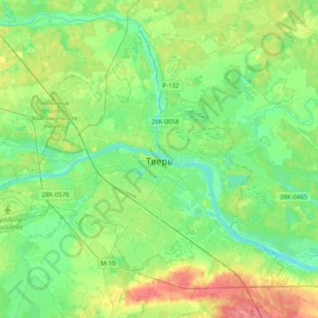
Name: Tver topographic map, elevation, terrain.

Location: Tver, Tver Oblast, Central Federal District, Russia (56.78332 35.72142 56.93606 36.06821)

Average elevation: 140 m

Minimum elevation: 119 m

Maximum elevation: 183 m

Other topographic maps

Click on a map to view its topography, its elevation and its terrain.

Petrovskoye

Russia > Tver Oblast > Kalininsky District

Average elevation: 169 m

Konakovo

Russia > Tver Oblast > Konakovsky District

Average elevation: 131 m

Peno

Russia > Tver Oblast > Penovsky District

Average elevation: 210 m

Устье

Russia > Tver Oblast > Kalininsky District

Average elevation: 139 m

Stan

Russia > Tver Oblast > Likhoslavlsky District

Average elevation: 182 m

Gear up for your next adventure:

🔥Camping Stove - Portable stoves to cook outdoors with ease
Tent Footprint - Protect tent floor and increase durability
🧰Emergency Multi-Tool - Compact multi-tool for outdoor survival
🥾Lightweight Hiking Boots - Boots for comfort and mobility on long hikes
🧰Multitool Knife - Compact and versatile tool for outdoor use

As an Amazon Associate, this site earns from qualifying purchases at no extra cost to you.