Geolocate

Point Wells topographic map

Click on the map to display elevation.

About this map

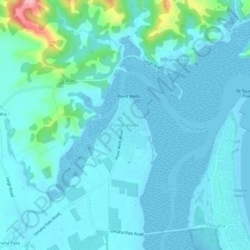
Name: Point Wells topographic map, elevation, terrain.

Location: Point Wells, Rodney, Auckland, 0986, New Zealand (-36.34394 174.73671 -36.30394 174.77671)

Average elevation: 22 m

Minimum elevation: 0 m

Maximum elevation: 185 m

Other topographic maps

Click on a map to view its topography, its elevation and its terrain.

Helensville

New Zealand > Auckland > Rodney

Average elevation: 21 m

Dome Forest

New Zealand > Auckland > Rodney

Average elevation: 168 m

Cowan Bay

New Zealand > Auckland > Rodney > Snells Beach

Average elevation: 22 m

Lake Rototoa

New Zealand > Auckland > Rodney

Average elevation: 102 m

Taupaki Estate

New Zealand > Auckland > Rodney > Kumeū

Average elevation: 37 m

Omaha Beach

New Zealand > Auckland > Rodney > Omaha

Average elevation: 3 m

Gear up for your next adventure:

🦟Insect Repellent - Keep mosquitoes and black flies away in wooded areas
Lightweight Backpacking Tent - Compact tent for efficient hiking trips
🦶Anti-Blister Balm - Prevents friction and hotspots during long ascents
🎒Fully Waterproof Backpack - Total protection for photography gear and electronics
🔪Outdoor Multitool - Versatile tool for repairs and food prep in the wild

As an Amazon Associate, this site earns from qualifying purchases at no extra cost to you.