
Thank you for supporting this site ❤️
Make a donation
Make a donation
Gear up for your next adventure:
As an Amazon Associate, this site earns from qualifying purchases at no extra cost to you.
Campofrío topographic map
Click on the map to display elevation.
Thank you for supporting this site ❤️
Make a donation
Make a donation
Gear up for your next adventure:
As an Amazon Associate, this site earns from qualifying purchases at no extra cost to you.
About this map
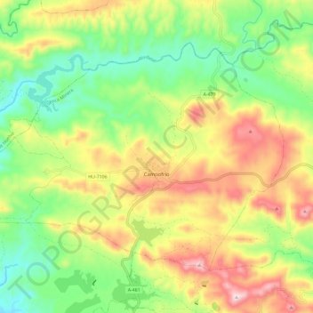
Name: Campofrío topographic map, elevation, terrain.
Location: Campofrío, Cuenca Minera, Huelva, Andalusië, Spanje (37.73742 -6.64537 37.80391 -6.52971)
Average elevation: 431 m
Minimum elevation: 242 m
Maximum elevation: 686 m
Thank you for supporting this site ❤️
Make a donation
Make a donation
Gear up for your next adventure:
As an Amazon Associate, this site earns from qualifying purchases at no extra cost to you.