
Thank you for supporting this site ❤️
Make a donation
Make a donation
Gear up for your next adventure:
As an Amazon Associate, this site earns from qualifying purchases at no extra cost to you.
Bagafa topographic map
Click on the map to display elevation.
Thank you for supporting this site ❤️
Make a donation
Make a donation
Gear up for your next adventure:
As an Amazon Associate, this site earns from qualifying purchases at no extra cost to you.
About this map
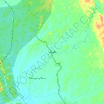
Name: Bagafa topographic map, elevation, terrain.
Location: Bagafa, Bokafa, South Tripura District, Tripura, 799144, India (23.26868 91.52527 23.34868 91.60527)
Average elevation: 35 m
Minimum elevation: 16 m
Maximum elevation: 93 m
Thank you for supporting this site ❤️
Make a donation
Make a donation
Gear up for your next adventure:
As an Amazon Associate, this site earns from qualifying purchases at no extra cost to you.