
South Omo topographic map
Interactive map
Click on the map to display elevation.
About this map
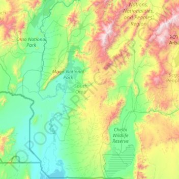
Name: South Omo topographic map, elevation, terrain.
Location: South Omo, Nations du Sud, Éthiopie (4.43883 35.78912 6.46212 37.06678)
Average elevation: 958 m
Minimum elevation: 360 m
Maximum elevation: 3,505 m
Other topographic maps
Click on a map to view its topography, its elevation and its terrain.
አርባ ምንጭ / Arba Minch
Éthiopie > Nations du Sud > አርባ ምንጭ / Arba Minch
አርባ ምንጭ / Arba Minch, Gamo Gofa, Nations du Sud, 40, Éthiopie
Average elevation: 1,455 m
Emdibir
Éthiopie > Nations du Sud > Emdibir
Emdibir, Guraghe, Nations du Sud, Éthiopie
Average elevation: 2,084 m
Kembata Alaba Tembaro
Kembata Alaba Tembaro, Nations du Sud, Éthiopie
Average elevation: 1,913 m