
Make a donation
Gear up for your next adventure:
As an Amazon Associate, this site earns from qualifying purchases at no extra cost to you.
Quinçay topographic map
Click on the map to display elevation.
Make a donation
Gear up for your next adventure:
As an Amazon Associate, this site earns from qualifying purchases at no extra cost to you.
Quinçay
La forêt de Vouillé est située tout près de la commune de Quinçay. C'est un important massif domanial de 1 500 hectares. Elle couvre un plateau à topographie très plane et d'altitude modeste : entre 130 m et 140 m en moyenne.
Make a donation
Gear up for your next adventure:
As an Amazon Associate, this site earns from qualifying purchases at no extra cost to you.
About this map
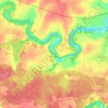
Name: Quinçay topographic map, elevation, terrain.
Average elevation: 123 m
Minimum elevation: 79 m
Maximum elevation: 149 m
Make a donation
Gear up for your next adventure:
As an Amazon Associate, this site earns from qualifying purchases at no extra cost to you.
Other topographic maps
Click on a map to view its topography, its elevation and its terrain.
Châtellerault
France > Nouvelle-Aquitaine > Vienne > Châtellerault > Châtellerault
Average elevation: 79 m
Make a donation
Gear up for your next adventure:
As an Amazon Associate, this site earns from qualifying purchases at no extra cost to you.