Geolocate

Morley topographic map

Click on the map to display elevation.

About this map

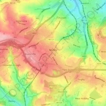
Name: Morley topographic map, elevation, terrain.

Location: Morley, Leeds, West Yorkshire, England, United Kingdom (53.71387 -1.63883 53.77082 -1.56792)

Average elevation: 119 m

Minimum elevation: 43 m

Maximum elevation: 187 m

Other topographic maps

Click on a map to view its topography, its elevation and its terrain.

Skelton Woods

United Kingdom > England > Leeds

Average elevation: 119 m

Guiseley

United Kingdom > England > Leeds

Average elevation: 140 m

Gear up for your next adventure:

🧣Merino Neck Gaiter - Protects against wind, sun, and cold at high altitudes
🧢Beanie Hat - Keep your head warm in cold weather
🧥Softshell Hiking Jacket - The perfect balance of wind protection and breathability
🛌Down Sleeping Bag - Superior warmth-to-weight ratio for cold nights
🐕Hiking Dog Pack - Let your canine companion carry their own water and food

As an Amazon Associate, this site earns from qualifying purchases at no extra cost to you.