
Belgrade topographic map
Click on the map to display elevation.
About this map
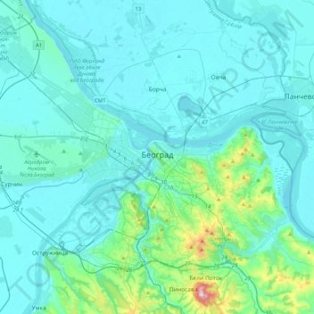
Name: Belgrade topographic map, elevation, terrain.
Location: Belgrade, City of Belgrade, Central Serbia, Serbia (44.68805 20.22138 44.94269 20.62321)
Average elevation: 108 m
Minimum elevation: 65 m
Maximum elevation: 491 m
Other topographic maps
Click on a map to view its topography, its elevation and its terrain.
Вранићки Тарајиш
Serbia > City of Belgrade > Barajevo Urban Municipality > Vranic
Average elevation: 162 m