
Thank you for supporting this site ❤️
Make a donation
Make a donation
Gear up for your next adventure:
As an Amazon Associate, this site earns from qualifying purchases at no extra cost to you.
Frohnleiten topographic map
Click on the map to display elevation.
Thank you for supporting this site ❤️
Make a donation
Make a donation
Gear up for your next adventure:
As an Amazon Associate, this site earns from qualifying purchases at no extra cost to you.
About this map
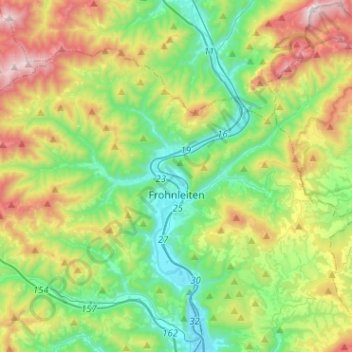
Name: Frohnleiten topographic map, elevation, terrain.
Location: Frohnleiten, Bezirk Graz-Umgebung, Styria, 8130, Austria (47.21764 15.15976 47.34361 15.41418)
Average elevation: 822 m
Minimum elevation: 397 m
Maximum elevation: 1,688 m
Thank you for supporting this site ❤️
Make a donation
Make a donation
Gear up for your next adventure:
As an Amazon Associate, this site earns from qualifying purchases at no extra cost to you.