Geolocate

Weinheim topographic map

Click on the map to display elevation.

About this map

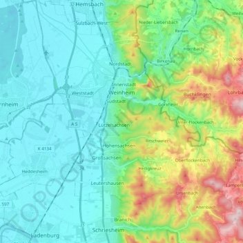
Name: Weinheim topographic map, elevation, terrain.

Location: Weinheim, Rhein-Neckar-Kreis, Baden-Württemberg, 69469, Germany (49.46824 8.60334 49.59384 8.78047)

Average elevation: 198 m

Minimum elevation: 90 m

Maximum elevation: 534 m

Gear up for your next adventure:

🛏️Sleeping Bag - Warm and compact sleeping bags for outdoor camping
🥾Durable Hiking Shoes - Long-lasting shoes for frequent hiking
🌡️Emergency Mylar Blankets - Compact thermal protection for unexpected nights outdoors
🧥Packable Rain Jacket - Breathable waterproof layer for unpredictable weather
🧦Thermal Socks - Warm socks for winter hiking or camping

As an Amazon Associate, this site earns from qualifying purchases at no extra cost to you.