Geolocate

Heppenheim topographic map

Click on the map to display elevation.

About this map

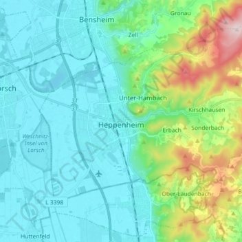
Name: Heppenheim topographic map, elevation, terrain.

Location: Heppenheim, Kreis Bergstraße, Hesse, 64646, Germany (49.60310 8.58889 49.68129 8.73108)

Average elevation: 177 m

Minimum elevation: 89 m

Maximum elevation: 533 m

Gear up for your next adventure:

🗺️Topographic Maps - Detailed maps to explore trails, mountains, and wilderness areas
🧥Softshell Hiking Jacket - The perfect balance of wind protection and breathability
🎒Hiking Backpack - Lightweight and ergonomic backpacks for day hikes or multi-day treks
Lightweight Camping Tent - Portable shelter optimized for Canadian backcountry camping
🧥Packable Rain Jacket - Breathable waterproof layer for unpredictable weather

As an Amazon Associate, this site earns from qualifying purchases at no extra cost to you.