Geolocate

Visnagar topographic map

Click on the map to display elevation.

Visnagar

Visnagar is located at 23°42′N 72°33′E / 23.7°N 72.55°E / 23.7; 72.55 at average elevation of 117 metres.

Wikipedia (CC-BY-SA 3.0)

About this map

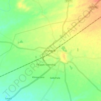
Name: Visnagar topographic map, elevation, terrain.

Location: Visnagar, Visnagar Taluka, Mahesana, Gujarat, 384300, India (23.66368 72.50046 23.74368 72.58046)

Average elevation: 126 m

Minimum elevation: 108 m

Maximum elevation: 146 m

Gear up for your next adventure:

🥾Hiking Gaiters - Protect legs and shoes from mud, snow, and debris
🛶Kayak Accessories - Essential gear for safe and fun kayaking adventures
Camping Tent - Weather-resistant tents suitable for 2 to 6 people
🥾Trail Running Shoes - Lightweight and durable shoes for trail running
🧢Hiking Hat - Sun-protective and breathable hats for long treks

As an Amazon Associate, this site earns from qualifying purchases at no extra cost to you.