Geolocate

Birkenau topographic map

Click on the map to display elevation.

About this map

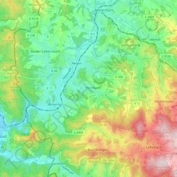
Name: Birkenau topographic map, elevation, terrain.

Location: Birkenau, Kreis Bergstraße, Hesse, 69488, Germany (49.53505 8.68031 49.60197 8.77624)

Average elevation: 261 m

Minimum elevation: 112 m

Maximum elevation: 531 m

Gear up for your next adventure:

🎒Backpack Rain Cover - External shield to keep your entire pack dry
🧥Thermal Layer - Insulating layer for cold outdoor conditions
Backpacking Tent - Lightweight tent for long-distance hiking trips
🧣Evaporative Cooling Towel - Beat the heat during intense summer climbs
🧦Hiking Liner Socks - Thin base layer to prevent friction and blisters

As an Amazon Associate, this site earns from qualifying purchases at no extra cost to you.