
Thank you for supporting this site ❤️
Make a donation
Make a donation
Gear up for your next adventure:
As an Amazon Associate, this site earns from qualifying purchases at no extra cost to you.
Vaccarezza topographic map
Click on the map to display elevation.
Thank you for supporting this site ❤️
Make a donation
Make a donation
Gear up for your next adventure:
As an Amazon Associate, this site earns from qualifying purchases at no extra cost to you.
About this map
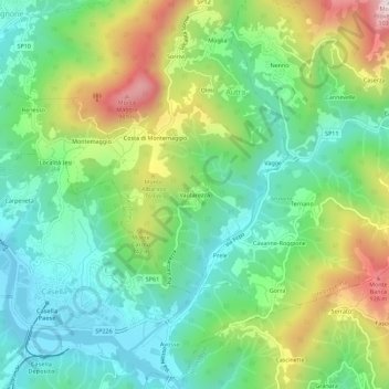
Name: Vaccarezza topographic map, elevation, terrain.
Location: Vaccarezza, Autra, Savignone, Genova, Liguria, 16015, Italia (44.52548 8.99704 44.56548 9.03704)
Average elevation: 599 m
Minimum elevation: 388 m
Maximum elevation: 1,014 m
Thank you for supporting this site ❤️
Make a donation
Make a donation
Gear up for your next adventure:
As an Amazon Associate, this site earns from qualifying purchases at no extra cost to you.