Geolocate

Gescher topographic map

Click on the map to display elevation.

About this map

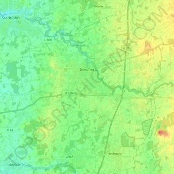
Name: Gescher topographic map, elevation, terrain.

Location: Gescher, Kreis Borken, North Rhine-Westphalia, 48712, Germany (51.88367 6.92557 52.00498 7.09019)

Average elevation: 64 m

Minimum elevation: 44 m

Maximum elevation: 103 m

Other topographic maps

Click on a map to view its topography, its elevation and its terrain.

SO2

Germany > North Rhine-Westphalia > Kreis Borken > Bocholt

Average elevation: 32 m

Gear up for your next adventure:

🪜Heavy Duty Carabiners - Multi-use clips for securing gear to your backpack
🔭Compact Binoculars - Lightweight optics for scouting trails and wildlife
👟Leg Gaiters - Keep debris, mud, and snow out of your boots
🥾Trail Hiking Boots - Supportive boots for rough trails
🔭Outdoor Binoculars - Lightweight binoculars for birdwatching and hiking

As an Amazon Associate, this site earns from qualifying purchases at no extra cost to you.