
Make a donation
Gear up for your next adventure:
As an Amazon Associate, this site earns from qualifying purchases at no extra cost to you.
Bad Liebenstein topographic map
Click on the map to display elevation.
Make a donation
Gear up for your next adventure:
As an Amazon Associate, this site earns from qualifying purchases at no extra cost to you.
Bad Liebenstein
Die Höhe Bad Liebensteins wird mit 344 m über Normalnull angegeben. Dabei handelt es sich um die Höhe des ehemaligen Bahnhofes, während der tiefste Punkt bei Meimers mit 267 m ü. NN liegt, befindet sich der höchste Punkt mit ca. 540 m ü. NN unterhalb des Frauenberges.
Make a donation
Gear up for your next adventure:
As an Amazon Associate, this site earns from qualifying purchases at no extra cost to you.
About this map
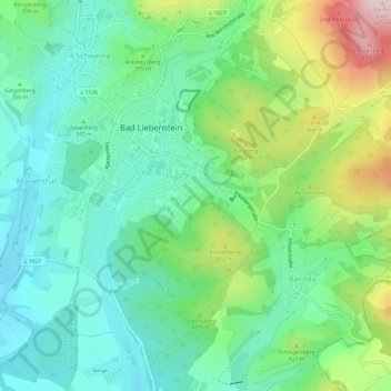
Name: Bad Liebenstein topographic map, elevation, terrain.
Location: Bad Liebenstein, Wartburgkreis, Thüringen, 36448, Deutschland (50.79273 10.33540 50.83076 10.39269)
Average elevation: 354 m
Minimum elevation: 261 m
Maximum elevation: 560 m
Make a donation
Gear up for your next adventure:
As an Amazon Associate, this site earns from qualifying purchases at no extra cost to you.