Geolocate

Odensvi topographic map

Click on the map to display elevation.

About this map

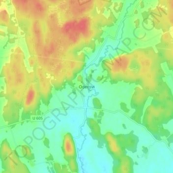
Name: Odensvi topographic map, elevation, terrain.

Location: Odensvi, Köpings kommun, Västmanland County, Sweden (59.56398 15.96818 59.60398 16.00818)

Average elevation: 42 m

Minimum elevation: 18 m

Maximum elevation: 74 m

Other topographic maps

Click on a map to view its topography, its elevation and its terrain.

Sala kommun

Sweden > Västmanland County

Average elevation: 72 m

Kungsörs kommun

Sweden > Västmanland County

Average elevation: 24 m

Gear up for your next adventure:

🧶550 Survival Paracord - Versatile utility cord for emergency repairs and rigging
🥾Approach Shoes - Shoes designed for climbing approaches and rugged trails
Camping Essentials - All-in-one gear for a comfortable camping trip
🕶️Polarized Sunglasses - Reduces glare from snow and water at high elevations
🧢Hiking Hat - Sun-protective and breathable hats for long treks

As an Amazon Associate, this site earns from qualifying purchases at no extra cost to you.