
Thank you for supporting this site ❤️
Make a donation
Make a donation
Gear up for your next adventure:
As an Amazon Associate, this site earns from qualifying purchases at no extra cost to you.
Ngargoyoso topographic map
Click on the map to display elevation.
Thank you for supporting this site ❤️
Make a donation
Make a donation
Gear up for your next adventure:
As an Amazon Associate, this site earns from qualifying purchases at no extra cost to you.
About this map
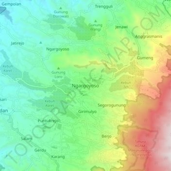
Name: Ngargoyoso topographic map, elevation, terrain.
Location: Ngargoyoso, Karanganyar, Central Java, Java, Indonesia (-7.64250 111.07748 -7.56250 111.15748)
Average elevation: 915 m
Minimum elevation: 476 m
Maximum elevation: 1,844 m
Thank you for supporting this site ❤️
Make a donation
Make a donation
Gear up for your next adventure:
As an Amazon Associate, this site earns from qualifying purchases at no extra cost to you.