Geolocate

Obermässing topographic map

Click on the map to display elevation.

About this map

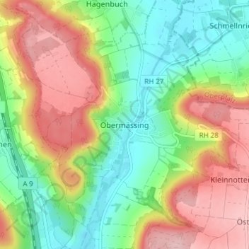
Name: Obermässing topographic map, elevation, terrain.

Location: Obermässing, Greding, Landkreis Roth, Bayern, Deutschland (49.09357 11.28735 49.13357 11.32735)

Average elevation: 468 m

Minimum elevation: 391 m

Maximum elevation: 566 m

Gear up for your next adventure:

🌡️Emergency Mylar Blankets - Compact thermal protection for unexpected nights outdoors
🏃Hydration Running Vest - Carry water and maps close to your body for speed
🕯️Camping Lantern - Illuminates your entire campsite with high-efficiency LEDs
🥽Outdoor Goggles - Protective eyewear for outdoor activities
🧼Travel Hand Sanitizer - Keep hands clean when water is scarce

As an Amazon Associate, this site earns from qualifying purchases at no extra cost to you.