Geolocate

Montecampano topographic map

Click on the map to display elevation.

About this map

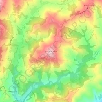
Name: Montecampano topographic map, elevation, terrain.

Location: Montecampano, Amelia, Terni, Umbria, 05022, Italy (42.49383 12.40882 42.53383 12.44882)

Average elevation: 219 m

Minimum elevation: 92 m

Maximum elevation: 345 m

Gear up for your next adventure:

🧦Hiking Liner Socks - Thin base layer to prevent friction and blisters
🧥Insulated Jacket - Keep warm in cold outdoor conditions
Camping Groundsheet - Protect your tent from moisture and dirt
🧢Beanie Hat - Keep your head warm in cold weather
🏃Hydration Running Vest - Carry water and maps close to your body for speed

As an Amazon Associate, this site earns from qualifying purchases at no extra cost to you.