
Make a donation
Gear up for your next adventure:
As an Amazon Associate, this site earns from qualifying purchases at no extra cost to you.
McAlpin topographic map
Click on the map to display elevation.
Make a donation
Gear up for your next adventure:
As an Amazon Associate, this site earns from qualifying purchases at no extra cost to you.
About this map
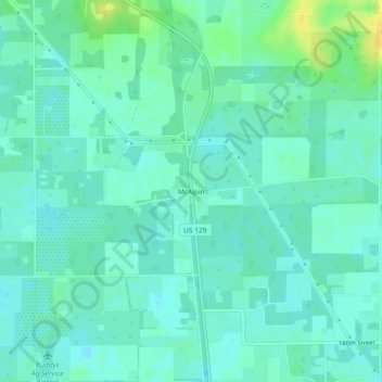
Name: McAlpin topographic map, elevation, terrain.
Location: McAlpin, Suwannee County, Florida, United States (30.11912 -82.97180 30.15912 -82.93180)
Average elevation: 31 m
Minimum elevation: 24 m
Maximum elevation: 49 m
Make a donation
Gear up for your next adventure:
As an Amazon Associate, this site earns from qualifying purchases at no extra cost to you.
Other topographic maps
Click on a map to view its topography, its elevation and its terrain.
Live Oak
United States > Florida > Suwannee County
Geographically, Suwannee County is situated on a limestone bed riddled with underground freshwater streams, which surface in dozens of beautiful springs. This phenomenon of "Karst topography" gives the area a local supply of renewable fresh water and abundant sources of fishing. The county is known as a…
Average elevation: 33 m