Geolocate

Silverton topographic map

Click on the map to display elevation.

About this map

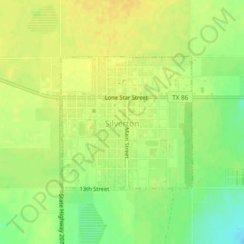
Name: Silverton topographic map, elevation, terrain.

Location: Silverton, Briscoe County, Texas, United States (34.46410 -101.31290 34.47876 -101.29516)

Average elevation: 998 m

Minimum elevation: 981 m

Maximum elevation: 1,007 m

Other topographic maps

Click on a map to view its topography, its elevation and its terrain.

Silverton

United States > Texas > Briscoe County

Average elevation: 998 m

Gear up for your next adventure:

🧥Thermal Fleece Jacket - Versatile insulation for changing mountain temperatures
💧Filtered Water Bottle - Safe drinking water on the go
🧢Hiking Hat - Sun-protective and breathable hats for long treks
🛌Down Sleeping Bag - Superior warmth-to-weight ratio for cold nights
🥾Hiking Shoes - Durable and comfortable shoes for trail hiking

As an Amazon Associate, this site earns from qualifying purchases at no extra cost to you.